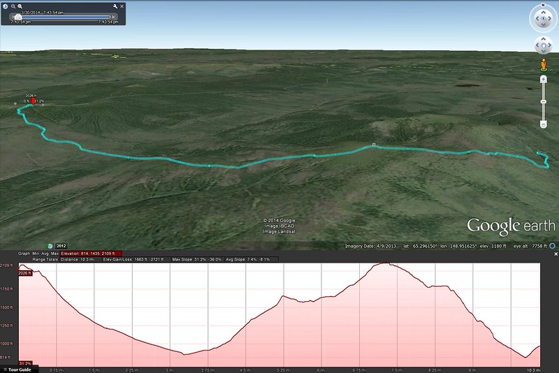
Click here to open an interactive map in a new tab.
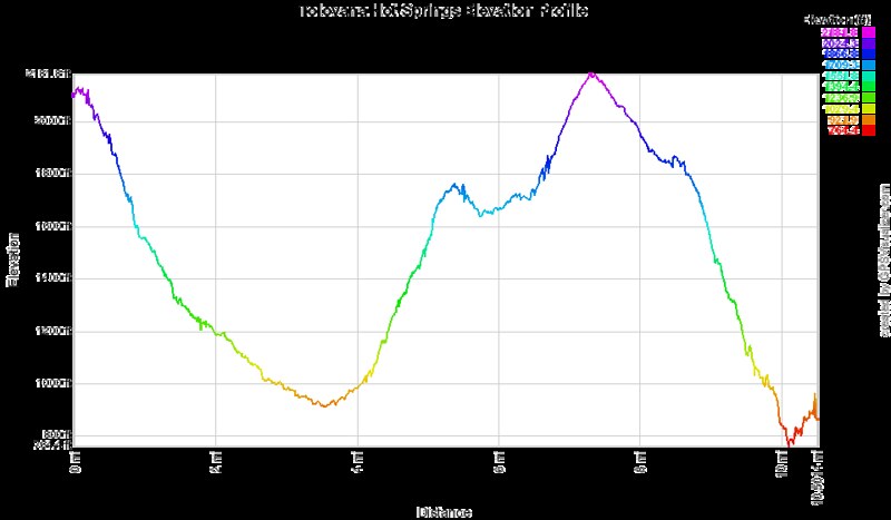
And here's an elevation profile color-coded to match the interactive map:

I made a trip out to Tolovana Hot Springs on March 30-31 with a few friends. It was my first time out there and my first time trekking while carrying my gear on a sled, and I thought I'd share a few pictures and thoughts.
First, the trail itself. It's 10.1 miles from the parking area at Elliot Highway mile 93. There are sign posts every mile on the trail so it's easy to keep track of progress. From the trailhead it's a drop of 1200ft into a valley, then across the valley itself which is fairly wide and flat, then over the top of Tolovana Dome; ~1300ft up then ~1100ft down the other side. It's really quite a large hill to drag a sled over; we seem to not have realized that, though the sled takes the weight off our backs, our legs still have to do the same amount of work in getting it up a hill. So we were cavalier and overloaded the sled, and I won't make that mistake again. I do think the sled was the way to go, just don't pack any more than you would carry on your back. The sled isn't 'look how much more we can carry now!', it's 'this stuff we were going to carry anyway won't stress our shoulders/backs all day'.
Route finding is super easy in winter since people ride snow machines out there every day. And snowshoes are unnecessary unless you want to go off trail. I wore a pair of YakTrax on my regular hiking boots and was quite happy with it. Summer may require more attention to stay on trail. I do intend to head out there again in summer so I'll find out. And if you're putting in the effort to hoof it out there rather than ride a snow machine, I recommend staying longer than one night.
I actually resurrected an old Magellan Triton 400 GPS unit I bought years ago that accepts custom maps so I could load the trail map and USGS topo maps of the area: I noticed that since the Triton only had 50MB of internal storage, I had expanded it with an SD card back in the day - 250MB. Big storage. It still works fine anyway, so I do actually have a detailed tracklog with elevation profile, and I should even be able to overlay that into Google Earth or Maps, but I can't seem to get the tracklog off the Triton through the SD card, and I have no idea where the weird proprietary USB cable is, so that'll have to wait until I get a new cable.
Parts of the trail have tons of ptarmigan/grouse tracks wandering around, especially the area in the valley. If you pass through in the morning you'd probably have a good chance of plugging a couple for dinner. We only saw one when we walked through in mid-afternoon, and it flew away while my shotgun was still on the sled.
We stayed in the Cedar Cabin, which was pretty nice. And for soaking there are 3 tubs set up alongside the hot springs creek the constantly get hot water cycled through them, and it's the best thing after a long hike. The lowermost tub has a pretty nice view to the south, and the middle tub is made of wood which grows lots of algae, so... I recommend the lower tub out of the two. We didn't try the upper tub.
I'm not sure what else I should say about it. Have some pictures:
The group (minus myself) near the top of Tolovana Dome, with Minto Flats off in the distance. Left-right Stephanie, Drew, Haley:
And facing back towards where we came from, with the car parked roughly where the ridgeline meets the sky just above Drew:
First moments after making it to the cabin and sitting down. Drew opens a bottle of gin, Haley puts together a hookah, Steph ties her hair back, and I take pictures. We all have our priorities :P
Then, everyone laid all their food on the table and we picked through it:
Cabin from the outside as we head down to the hot springs:
The middle tub:
Everyone out of focus in the lower tub. I'm a terrible photographer:
Thanks for the elevation profiles I posted a link to it on my blog.
ReplyDelete