
Indian Creek is a tributary of the Buffalo National River. You start by walking west on the Buffalo River Trail from Kyle's Landing. You turn left after only a couple hundred feet to stay on the BRT rather than the Old River Trail (horse trail). The trail goes over a hill, and about a half mile you come to a T intersection, where you take another left, then very quickly another T, where you take yet another left. This is the Indian Creek 'trail' - there's no official trail here, only a 'primitive route'. You will quickly come to the creek bed, and basically you just follow it upstream. There will be times when you're on slick solid rock, or mud through the grass, or loose rocks, or wading in the creek, so be prepared.
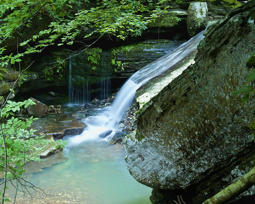
This is said to be one of the prettiest hikes in the area, and I believe it. The whole creek is filled with small waterfalls, pools, and cascades. I liked the way the water here slid down the rock at this spot, but couldn't figure out a good way to frame it.
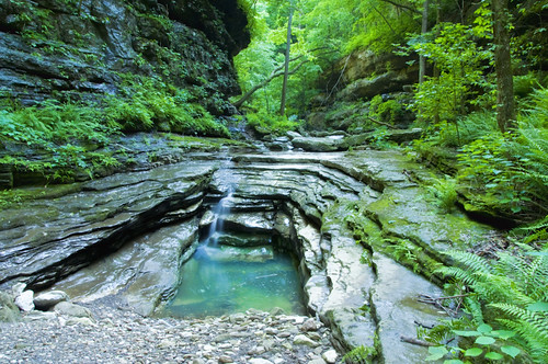
The bluffs close in to make a pretty tight canyon of a couple hundred feet deep. With very little light making it to the bottom, the dominant ground cover is ferns. The water has carved the rock into some interesting shapes. This one I call the 'Flintstones Bathtub'.
After a while, I started getting whiffs of a sweet poopy smell, which got stronger and more frequent. This is guano from the bat colony in the cave ahead. I've seen it referred to as 'Tunnel Cave', 'Arkansas Cave', and 'Horseshoe Cave'. Apparently you used to be able to use it to access further upstream, but that route has been forbidden since the endangered bats took up residence.
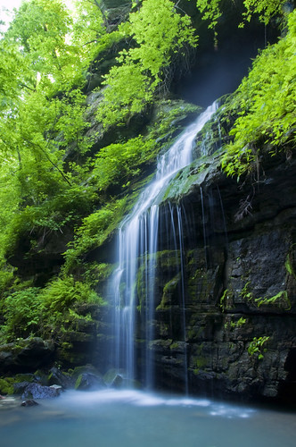
Just past Tunnel Cave there is a picturesque falls, and what appears to be a dead end.
Indeed, this was the end of the line for me the first time I came here. Going further requires some hairy moves that I decided against while by myself. So I came back two days later with two buddies, determined to go all the way.
After these falls, the trail definitely gets turned up a notch. The first step is to climb a 10 foot ledge on the right (facing the falls). When I came by myself, there was a rope here to help pull yourself up, but it was wet and old, and I wasn't sure it would hold a person. When we returned two days later, the rope had broke. Good thing I didn't try to climb it. Luckily, we brought our own. I tied the end to a carabiner and tossed it up and around a tree on top the ledge, then tied the ends together, so we had a 'double thick' rope. This was so we could retrieve the rope later. We pulled ourselves up to the tree, which was on about a 3 foot wide ledge below another 6 foot climb. From here we could put our back against the tree trunk and feet on the wall to chimney climb the rest of the way up.
We left the rope here because we'd need it on the way down, and tackled the next step, a Class 3 scramble a couple hundred feet up a steep, loose slope. At the top, we came into a large overhanging bluff shelter. Both sides of the shelter have a small ledge extending around the edge and out of sight. We tried the right side and found a cave, but didn't have any flashlights, so we left it alone. But from the right side we could see the ledge on the left side had a passage through the bluff and to the other side. We crawled around the left side ledge, which was less than a foot wide at points, with a very unpleasant fall as motivation to be careful.
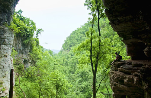
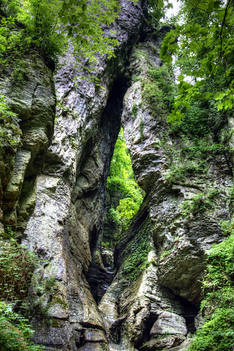
In the above picture, just behind Coty, you can see the opening to the passage. The passage is about 4 feet tall and 20 or 30 feet long, and there is enough light inside to see well. There are two other openings, one looks down on where you just came from, and the other comes out the other side of the bluff. From there you head to the right on a narrow grassy trail which is a little precarious in spots, but nothing compared to what you just did. It's a short walk, 5 or 10 minutes, to the 'Eye of the Needle', a large sandstone arch cut by the creek.
We got right up to the bottom, and there was a rope anchored somewhere up above if you want to climb higher. We climbed up to the first ledge, but the rock was very slick with moss, and it was starting to thunder, so we decided to turn back and climb back down before it started raining. I rigged a rope harness and we rappelled back to the ground.

We climbed back down to the creek, packed up our rope, and walked back to the car. All in all, it was only about a 5 mile hike, but it was a rough 5 miles. I'm already thinking about going back, we didn't get to stay at the Eye long enough to explore photographic options. I'd actually like to be there after dark and try lighting it with strobes. Another time, I guess.